|

©1999 www.arttoday.com
|
The team used a wide variety
of images from an international array of satellites.
|
by Toshibumi Sakata, Masahiro Etaya, Sakuji Yoshimura, Jiro Kondo, and
So Hasegawa
The Egyptian pyramids, easily the most famous monuments of the ancient
world, are scattered in the desert on the Nile's west bank. Built during
the Old Kingdom period (about 2800-2200 B.C.) and Middle Kingdom
(2040-1780 B.C.), the pyramids are heavily studied, but they still hold
riddles aplenty.
It is reasonable to suppose that, despite some 200 years of
archaeological explorations, some pyramids remain to be discovered in the
area, since the tombs of at least three kings Menkauhor (of the fifth
dynasty), Neferkare (seventh to eighth dynasty), and Ity (ninth to tenth
dynasty) have never been found. If we can find these pyramids in their
original state, the purpose and manner of construction and other lingering
questions might be answered.
Tokai University Research & Information Center (TRIC) has for
decades been using satellite data to survey and study archaeological
remains and paleoenvironments around the world. Recently we used data from
space, for the first time in Egyptology, to explore the "pyramid zone"
the Nile's west bank from Abu Rawash to Maidum.
A central question of our study is whether pyramids like those of the
three giant monuments of Giza could remain undiscovered. Khufu's pyramid,
known as the Great Pyramid, is about 230 meters (755 feet) on a side and
146 meters (479 feet) high. It is, of course, difficult to envision such a
huge complex being buried under that desert and escaping detection for
more than 4,000 years.
Such a pyramid almost certainly would have been looted, and perhaps
even demolished, during the social unrest that followed the end of the Old
Kingdom. Some collapsed and unfinished pyramids which look like
mountains of rubble or simply foundations without the dramatic stone
superstructure have been found; such ruined structures became the main
target in this study.
|
|
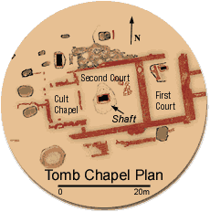
The site map of the Dahshur
North excavation reveals an elaborate tomb, probably that of an
important personage from the eighteenth or nineteenth Egyptian
dynasty.
|
The View from the Sky
A wide variety of satellite data in both optical and microwave
wavelengths was analyzed to search for traces of collapsed and unfinished
pyramids and other artificial objects invisible from the surface. In
general, each wavelength provides different information, and comparing the
various satellite views of the same area provides a rich source of data.
Microwave images in different wavelengths (each providing slightly
different information) were obtained for the target area from the Japanese
Earth Resources Satellite (JERS-1) and the European Union's European
Remote Sensing Satellite (ERS-1). These were studied to determine the
microwave signature of bedrock, limestone blocks, mud bricks, and other
archaeological objects, including pottery sherds and stone fragments. We
also examined optical satellite data from the French SPOT satellites,
American Landsat, and Russia's KVR-1000. In each case, the images were
analyzed to clarify the shape and other characteristics of known
archaeological remains, especially collapsed or unfinished pyramids.
The microwave images are made with "synthetic aperture radar" (SAR), a
process in which the spacecraft's motion is tapped to simulate a very long
antenna, which improves resolution. Short, repeated pulses of radio waves
(as many as 1,700 per second) are transmitted from the satellite, and the
backscatter (the echo from the ground) is collected and processed to
create the image.
The density of the object on or under the ground is determined by the
backscatter strength of the microwave signal; strong backscatter is
associated with artificial constructions, including pyramids and other
monuments. The European satellite uses C-band microwaves that display only
the surface undulations of the desert. The higher-frequency L-band images
of the Japanese spacecraft were much more effective at detecting buried
artificial constructions; the satellite readily sees beneath the dry
desert sand where optical images revealed nothing. We therefore
emphasized the JERS-1 images in our search for hidden objects.
Optical satellite images were used to clarify the shapes of known
collapsed or unfinished pyramids and their formation. We first identified
the spectral characteristics for the pyramids and other limestone
monuments in the Landsat image. We used the SPOT images to verify the
resolution needed to identify these structures. We found that monumental
constructions showed strong differences from the surrounding sand, and a
10-meter (33-foot) resolution is sufficient to identify pyramid-size
monuments. The two-meter (6.5-foot) resolution of the Russian KVR-1000 was
used to define the surface shapes of collapsed or unfinished pyramids,
which turn out to be quite distinctive.