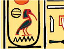
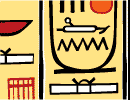
GALLERIES
 » General
 » Hieroglyphics
  PHOTO TOURS
 » Abu Simbel
 » Karnak
 » Kings Valley 5
 » Philae
 »
  GENERAL
 » Make Your
Own Cartouche
 » Buy Posters
 » Favorite Books
 » Daily Papyrus
 » Articles from
around the net
 » Maps of Egypt
 » Write a Papyrus
to the Pharaoh
 » Extended Search
  INTRO TO
 » Egypt
 » Hieroglyphics
 » Mummies
  DATES
 »
 » Events Timeline
 » Visual Timeline
 GODS&PHARAOHS
 » Gods
 » Pharaohs
  FLASH MOVIES
 » Journey Through Valley of the Kings
 » Pyramids Galore
 » Mummy Maker
 » Who Killed King Tutankhamun?
 » Build a Pyramid
 » Atlas of the Valley of the Kings
 » Screen Savers
 » Hiero Translator
 » Djoser Pyramid
 » Giza Plateau
 » Unwrapping the Mummies
 » Reincarnator
SPECIAL INTEREST
 » 3D Models
 » Multimedia Video
 » Amarna Period
 » King Tut
 » Seven Wonders
 » Women in Egypt
 » QuickTime Panoramas
  TEXTS
 » Book of the Dead
 » Egyptian Myths
 » Love Poems
 » Poetry & Proverbs
HIEROGLYPHICS
 » Alphabet
 » Common Words
 » Determinative
 » Gods
 » Hieratic
 » Kings
 » Numbers
 » Phonetic
 » Lessons
  VIRTUAL TOURS
 » Dendera
 » Giza Pyramids
 » Karnak
 » Saqqara
 » Solar Boat
  GAMES & MISC
 » Get these Books
 » Make Your
Own Cartouche
 » Calculator
 » Quick Quiz
 » Trivia Game
 » VE Breakout
 » Scarab Puzzle
 » Adopt a Mummy
 » Wallpapers
 » Kids Corner
 » Egyptian Games
 » Egyptian Stationary
 » Egyptian Music
 » Egyptian Encycoledia
  EGYPT SKIES
 » Live Satellite
 » Space Shuttle
 » Hale-Bopp
  LINKS
 » Egyptologists
 » Rings
 » Old Site
 » Other Links
 » Egypt Sites


Click Here to Create a Custom Cartouche of Your Name or Phrase with the Fun and Popular Hieroglyph Translator
 
Orientation


Special thanks to Carnegie Museums of Natural History for this introduction to Ancient Egypt.
Because of its location at the crossroads of the African and Asian continents, Egypt has been an important geographical and political power since the earliest times. In ancient times, the boundaries of Egypt were the Mediterranean Sea to the north and Elephantine (modern Aswan) to the south. Its eastern and western boundaries were in the high desert on either side of the narrow strip of Nile valley and low desert. The Nile River, the most important geographic feature in the area, runs the length of the country, flowing from south to north.

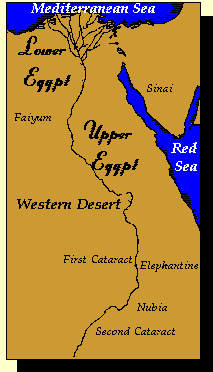
Ancient Egypt was divided into two regions: Upper and Lower Egypt. Lower (northern) Egypt consisted of the Nile River's delta made by the river as it empties into the Mediterranean. Today the Delta is fifteen thousand square miles of alluvium (silt), which has been deposited over the centuries by the annual flooding of the Nile. For much of Egypt's history, this area was only thinly settled, although it was used as a grazing area for cattle.

Upper Egypt was the long, narrow strip of ancient Egypt located south of the Delta. This area is composed of four topographic zones: the Nile River, the floodplain, the low desert, and the high desert. Each of these zones was exploited differently by the ancient Egyptians.

Throughout their history, Egyptians shared a common language, world view, and institutional structure, as well as a common territory. Ancient Egyptians had a keen sense of the distinctiveness and superiority of their culture, and they struggled to maintain it. Many of the rituals they performed encouraged continuity with earlier periods of their history that they visualized as ideal.


All trademarks and copyrights on this page are owned by their respective owners.
The Rest Copyright 1998-2012 All Rights Reserved www.Virtual-Egypt.com

Copyright and Disclaimer | Privacy Policy | E-Mail the Virtual Pharaoh


Macromedia Flash
Hieroglyphic
Translator

Fun with Hiero

Macromedia Flash
Hieroglyphic
Screen Saver
Screen Saver